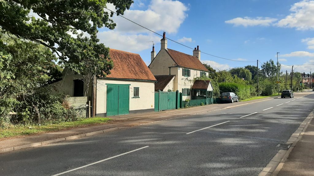
A colleague noticed that road names have recently been installed on the roads serving the new Stanbury View estate. On the lefthand side of Basingstoke Road as you climb up the hill from Three Mile Cross, the estate is of course named after Stanbury, the house built on the opposite side of the road for Frederick Alfrey in the 1860s. (You would have to have outstanding eyesight to “view” Stanbury as it was demolished after a fire in the 1960s.)
Left. Lietenant’s Cottage, formerly the Star
The full history of Stanbury and the surrounding estate can be found in our book More from our Village of Spencers Wood, which is still available at the reduced price of £5.00.
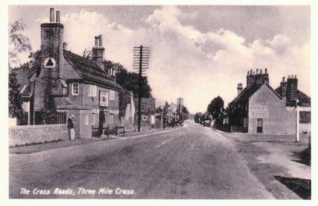
Star Rise, one of the two roads into Stanbury View, commemorates a further episode from local history. Although now better known as the Lieutenant’s Cottage, this was once the Star, described as a beer house – less classy than an inn – run, at the time of the 1851 census, by William and Mary Marlow. At that time, due to its position on the main road to Basingstoke, and beyond that Portsmouth, Three Mile Cross was a regular staging post for coaches and supported a number of pubs. In the same 1851 census, a total of five, including the Star, are recorded: The Fox and Horses, run by Joel and Lucy Brent, The George and Dragon, run by George Banks and his sister Sarah, The Rose and Crown run by George and Mary Strong and the Swan run by William and Mary Barry.
The best known resident of Three Mile Cross at that time was Mary Mitford, the author of Our Village. Mayflower Meadow, the other new road into the estate, is not named after the ship of that name but after one of Mary Mitford’s dogs, Mayflower, or May as she calls her. With Lizzie, her other dog, they were her companions on her many trips around the village.
Right. The George and Dragon one of five pubs in Three Mile Cross in the 1850s.
Sometimes you find unexpected links between projects. In this case, while researching the history of the Royal Oak as part of our project studying the history of the pubs in Shinfield Parish – on which we are working with Shinfield Local History Society – one of our members established that in 1906 the pub was supplied by Dymore Brown’s Royal Albert Brewery in Reading. We had previously encountered the Dymore Brown family as part of our research into the history of Three Mile Cross Methodist Chapel, a project we completed ten years ago.
The Family were committed and enthusiastic Methodists giving generously to a number of local churches including the chapel in Three Mile Cross and Mrs Janet Dymore Brown, wife of the ownwr, laid the foundation stone of the Chapel. The Group’s book, subtitled The Little Village Chapel in the Meadow is still available, price £4.00.
If you know the identity of this group of men, gathered outside the former Red Lion pub or can can help us with our current project on the pubs of Shinfield – photos or stories of those who worked or frequented any of our pubs, many now lost, please get in touch.
This is the first post – there’ll be another to follow – about the Elisha family in our series about people commemorated in local road names. For those that haven’t come across Elisha Close before, it’s off Beech Hill Road on your right as you leave Spencers Wood…
The Elisha family were builders, farmers and farm workers who have lived in Shinfield parish since at least 1602, when a William Elisha married Elizabeth Pither in St. Mary’s church, Shinfield on 10th October. This post looks at two generations of the family, both named John Elisha, and the wife of the second John Elisha, Dorothy Davis, who lived at the turn of the eighteenth and nineteenth centuries.
The first John Elisha and his brother, James were both successful builders and bricklayers, each owning their own brickworks, and were followed into the business by their sons. John Elisha’s life spanned pretty much the entire eighteenth century, from his birth in 1707 to his death in 1787. In his will, made in the last months of his life, he describes himself as a Bricklayer, living in Swallowfield. From as early as 1768 we can see from the Poll Book that although he lived in Swallowfield, he owned property in Shinfield and thus had the right to vote – then restricted to property owners. At this time Ballots were not secret and how people voted was recorded and published in poll books. In this case, like most voters, John Elisha voted for the sitting MPs, Thomas Craven and Arthur Vansittart. The third contestant, John Stone of Goldwell, was considered a weak candididate nevertheless Vansittart is said to have spent £5,000, about £440,000 today, on securing his re-election.
We can see from his will that when he died in 1787 John Elisha had continued to live in Swallowfield but by then had property in Shinfield, Three Mile Cross and Farley Hill, including owning the Blacksmith’s shop in Shinfield. His estate was divided between his son, John Elisha and his daughter, Elizabeth and her husband William Collins. From his father’s will we know that John Elisha the younger was living in Three Mile Cross at this time. In his own will, made a decade later in 1796, he too describes himself as a bricklayer however, apart from a reference to “stock in trade” which might or might not relate to the building trade, his will is focused almost entirely on farming.
John the younger left everthing to his wife Dorothy for the rest of her life, providing she did not re-marry, with detailed instructions on how the farm was to be managed which give an insight into farming at the end of the eighteenth century. His son Richard, who had been working alongside his father, was to act as baliff and run the farm for his mother, buying and selling “and out of the profitts thereof keep up a sufficient stock of cattle and implements to manure, plough, sow and gather in the corn and grain growing thereon and to inbarn, house, rick, thresh out and carry the same to market and also to act and do everything to the best of his knowledge in [a] reasonable way to preserve and keep the Farm in an husbandlike state and manner”.
From the records of the Land Tax for 1798 we can see that Dorothy owned freehold property and land, including houses in Millworth Lane, Shinfield and Whitley Wood and held even more land as a tenant farmer, possibly including Hartley [Court] Farm. This was a profitable time to be a farmer, with increased yields due to the Agricultural Revolution and high prices as a result of shortages due to the Napoleonic wars. From John Elisha’s will we can see that the Elishas were mixed farmers raising horses and cattle and growing corn and hay. The corn and surplus cattle were sold while the straw from the corn and the hay were used for feed and bedding for the remaining cattle and horses.
When Dorothy died in 1806 it appears that the farm was sold up. Richard and his youngest brother, George appear to have moved to Shoreditch in London where they followed their father and grandfather as bricklayers. Their brother Thomas also became a bricklayer and is recorded in the 1841 census living in Earley with his son George, also a bricklayer. Only their oldest brother, another John Elisha, continued farming in Spencers Wood – more about him in a future blog.
Ever wondered about your street name? Who was Elizabeth Rout commemorated in the name Elizabeth Rout Close? What has Fullbrook Avenue to do with overflowing streams? The answer is very little. And Marlow Place has next to nothing to do with the town on the banks of the River Thames…
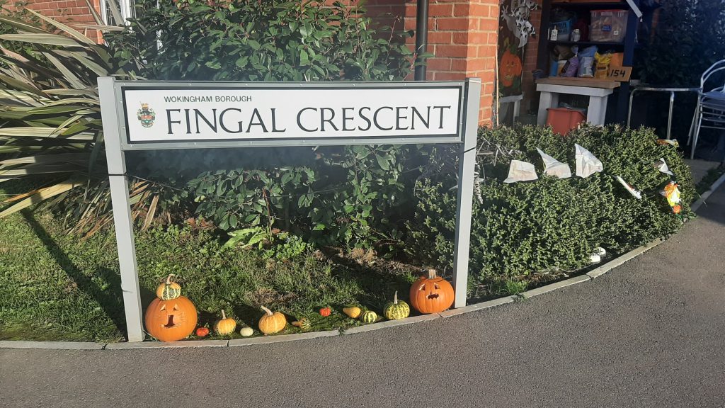
This is the first in a series of blogs in which we will explore the history behind our local road names, especially those associated with the new developments in Spencers Wood, Shinfield and Three Mile Cross. Today we are starting Appleby Walk, which you will find on your left as you walk down Fullbrook Avenue from Hyde End Road in Spencers Wood towards Ryeish Lane and the bus link to Shinfield, and Fingal Crescent, which you’ll find on your right a little further down Fullbrook Avenue just after it crosses Croft Road.
The Earl of Fingal was the major local landowner in the eighteenth century. In 1755 he had married Harriet Woolascot, the heiress of William Woolascot of Woolhampton. The Woolasots had been lords of the manor in Shinfield since 1623 when William Woolascot married an ealier heiress, Anna Martyn. On becoming lord of the manor, Fingal commissioned a survey of his new estates and the resulting map is the main source of our knowledge about the tenants who were farming his land at that time.
The Appleby family were one of his tenants and held most of the land that has recently been under development. In 1611 the land was part of Blackhouse Farm and was mentioned in Nicholas Russell’s Will of that year and was part of a Charity set up to pay 20 shillings a year (a pound for younger readers) to the poor of Shinfield village. Mrs Abbleby was named as the tenant on the Earl of Fingal’s estate map. She was descended from a Reading tailor named John Appleby, who was born in about 1620. The land was left to her relation the Revd. John Appleby on her death in 1787. The Revd’s wife Grace died in 1820 and he died in Nov 1825 in Easthorpe, Essex. Later maps show that the land was then left in the hands of trustees and remained in ‘Chancery’ until 1866 when the land was sold.
The Appleby family were one of his tenants and held most of the land that has recently been under development. In 1611 the land was part of Blackhouse Farm and was mentioned in Nicholas Russell’s Will of that year and was part of a Charity set up to pay 20 shillings a year (£1.00 for younger readers) to the poor of Shinfield village. Mrs Abbleby was named as the tenant on the Earl of Fingal’s estate map. She was descended from a Reading tailor named John Appleby, who was born in about 1620. The land was left to her relation the Revd. John Appleby
on her death in 1787. The Revd’s wife Grace died in 1820 and he died in November 1825 in Easthorpe, Essex. Later maps show that the land was then left in the hands of trustees and remained in ‘Chancery’ until 1866 when the land was sold.
In an attempt to make information easier to find we are consolidating previous posts on the Group’s Blog and publishing them in a new area on the website Our Village time Time. So far two themes have been completed, the first on The Village in War Time gathering together previous posts on the Great War and Second World War, including the letter from Maria Antonia Bertoni on her father’s experience as an Italian POW held at Stanbury Camp. The second theme to be completed is Settlement and landscape, bringing together posts on the many changes that have affected the village and surrounding countryside over the years. Future themes will include farms and farming and leisure and recreation.
If there are further improvements that you would like to see please leave a comment below or get in touch through our email.
It’s more than a year since our last post. Like so many other organisations the Local History Group has not been able to meet for many months but we are now up and running again.
We recently took part in two events: the Communi-Tea Cafe at Spencers Wood Village Hall on 18th September and St.Michael’s Church Fete on 25th September.
Future events will be published on our website. In the meanwhile why not visit the People section of the website and read about the life of Pioneering Nurse Louisa Parsons, 1855-1916 who was buried in Shinfield after serving in Egypt, South Africa and the USA.
Although Shinfield’s VE Day Commemorations had to be cancelled due to the current restrictions we’ve taken the opportunity to update our website to create an area about the impact of the Second World War, and the Great War, on the Village and its residents. This includes information from previous posts including accounts of evacuees and the impact of the wars on our village schools as well as new information.
The former United Reform Chapel, Basingstoke Road
We’ve also created a new Resources area on the website which will contain free downloadable files and information. With so many people taking advantage of the current restrictions to explore the area by bike or on foot, the first item to be uploaded is a history-focused walk along the Basingstoke Road.
Some people may feel that somewhere like this doesn’t have much of a history to speak of but we would beg to differ. All along the Basingstoke Road from Three Mile Cross to Swallowfield there are hints and clues to be found which add interest to an afternoon’s walk, for instance the old orchards that used to grow where Apple Tree Lane now stands, a reminder of the village’s former history of market gardening. No need to walk the whole distance in one go but if you’re feeling energetic…